Terrestrial and Aerial Laser Scanning

Geospatial services

We deliver high-definition laser scanning and mobile LiDAR survey services with submillimeter accuracy. Our scan-to-BIM solutions create precise digital twins for topographic surveys and asset documentation across industrial sectors.

High-Definition Reality Capture in Weeks, Not Months

We deliver high-definition laser scanning and mobile LiDAR survey services with submillimeter accuracy. Our scan-to-BIM solutions create precise digital twins for topographic surveys and asset documentation across industrial sectors.

We engineer reality capture solutions that perform where precision is non-negotiable. From submillimeter-accuracy terrestrial laser scanning and SLAM-enabled mobile LiDAR to UAV-integrated aerial survey systems, we acquire billions of georeferenced measurement points across industrial assets of any scale — offshore platforms, refineries, mining operations, and critical infrastructure.

Our Scan-to-BIM workflows transform this data into fully coordinated, dimensionally exact digital twins that eliminate fabrication mismatches, reduce costly rework, and give engineering teams the spatial confidence to move faster at every project stage. What traditional methods stretch across months, we deliver in weeks — high-accuracy, fully processed, decision-ready.

How We Capture Reality: Technology That Sees Everything

Our multi-platform approach deploys the right sensor for every scenario — ensuring no surface goes unmeasured and no detail is lost.

Terrestrial Laser Scanning (TLS)

High-density, survey-grade static scanning using phase-shift and time-of-flight instruments achieving positional accuracies of ±1–2 mm at ranges up to 350 m. Ideal for complex plant environments, confined spaces, and applications requiring the highest geometric fidelity — from refinery pipe racks to heritage façades.

Aerial LiDAR (UAV & Manned )

Drone-mounted and helicopter-borne LiDAR sensors capturing up to 1.5 million points per second across large-area sites, linear corridors, and elevated structures inaccessible to ground crews. Fully integrated with RTK/PPK GNSS and IMU systems delivering vertical accuracies of ±2–5 cm over kilometer-scale projects.
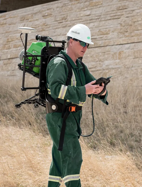
Mobile Mapping & SLAM LiDAR

Handheld and vehicle-mounted SLAM (Simultaneous Localization and Mapping) scanners enabling rapid walkthrough capture of tunnels, corridors, building interiors, and underground mining environments at speeds 10× faster than static methods — without sacrificing centimeter-level accuracy.

Hybrid Workflows

Our most complex projects combine all three platforms into a single georeferenced dataset. Terrestrial scans anchor millimeter-precision detail, aerial LiDAR extends coverage across inaccessible zones, and SLAM fills the gaps — all registered into one seamless, survey-controlled point cloud.

What We Deliver: Comprehensive Intelligence

HIGH-DEFINITION POINT CLOUD DATASETS

Industry-standard formats (LAS 1.4, E57, RCP, PTS, PLY) with complete metadata, ASPRS classification, RGB colorization, and intensity mapping. Submillimeter to centimeter accuracy point clouds serve as the authoritative geometric foundation for all downstream analysis — from structural engineering to predictive maintenance.

PROFESSIONAL CAD DRAWINGS

Dimensioned floor plans, elevations, cross-sections, and fabrication-grade detail drawings extracted directly from point cloud data maintaining survey-grade accuracy (±3 mm typical). Delivered in DWG, DXF, and PDF formats suitable for construction documents, fabrication shop drawings, and regulatory submission.

Intelligent BIM Models

Scan-to-BIM conversion delivering parametric Revit/IFC models at specified Levels of Development (LOD 200–500) in accordance with AIA and ISO 19650 standards. Models support design coordination, automated clash detection, MEP routing optimization, and lifecycle asset management.

Digital Twins

Interactive, data-rich 3D models integrating geometric scan data with live operational feeds — IoT sensors, SCADA systems, process historians, and analytical models. These dynamic digital twins enable real-time monitoring, scenario simulation, what-if analysis, and predictive decision-making across the entire asset lifecycle.

Industries We Serve

industry image

deliver image

Oil & Gas

Pipeline Route Survey | Facility Change Detection | Methane Emission Monitoring | | Offshore Platform
Surveillance | Oil Spill Detection | SCADA-GIS Integration I AL/ML based Asset Moniroting

industry  image

industry image

AEC & Building Documentation

Scan-to-BIM Conversion | Construction Progress Monitoring | As-Built Verification | Renovation Design Support |
MEP Coordination

industry  image

deliver image

Infrastructure & Transportation

Traffic flow simulation I Urban Planning | Citizen Service Mapping | Emergency Management | Public Health
Mapping I Rail Network Monitoring | InSAR Settlement Monitoring I Digital twin Development

industry image

deliver image

Mining & Quarrying

Mineral Mapping | Open Pit Volume Monitoring | Tailings Dam Surveillance | Mining Subsidence Monitoring |
Progressive Rehabilitation Tracking | Environmental Compliance Reporting I HSE Virtual Tour

industry  image

industry image

Manufacturing & Industrial

Plant Documentation | Equipment Routing | Maintenance Planning | Digital Twins | Risk Management | VR HSE
Training

industry  image

deliver image

Utilities & Networks

Underground Mapping | Route Planning & Conflict Detection | Asset Documentation | Damage Assessment | Safety
Verification

industry image

deliver image

Coastal, Marine & Hydrographic

Shoreline Change Detection | Satellite Bathymetry | Coastal Erosion Monitoring | Marine Habitat Mapping | Flood
Inundation Modelling | Sediment Transport Analysis

industry  image

industry image

Environmental Management

Environmental Impact Assessment | Habitat Classification | Carbon Accounting | Water Quality Monitoring | Land
Degradation Assessment | Climate Change Indicators | Sustainability Reporting

industry  image

deliver image

Defense, Security & Intelligence

Force Deployment Planning | Terrain Analysis | Border Surveillance Analytics | Geospatial Intelligence (GEOINT)
And Image Intelligence (IMINT)

Our Methodology: Precision at Every Stage

A proven four-stage process ensuring accuracy, compliance, and actionable insights

deliver image

Plan with Intelligence

Before mobilizing, we begin with a data-driven understanding of your asset environment. We perform a comprehensive site intelligence review — analyzing existing drawings, access limitations, hazardous zones, operational constraints, and required accuracy levels.

deliver image

Precision Field Acquisition with real time QC

Our field teams deploy fully calibrated instruments in strict accordance with manufacturer specifications and project QA protocols. Intelligent workflows deliver real-time on-site feedback on coverage, registration integrity, and data quality

deliver image

AI-Driven Data Processing & Extraction

Curates raw data, Guides AI, Validates Output into actionable digital intelligence through a hybrid pipeline of advanced algorithms, machine learning models, and expert review.

deliver image

Decision-Ready Deliverables

Outputs are not merely models but enterprise-ready information assets. All datasets undergo independent quality assurance audits. We ensure your organization can immediately operationalize the data for planning, maintenance, and strategic decision-making.

Case Studies

We're building a greener tomorrow. Our solutions optimize operations, cut waste, and lower emissions, supporting net-zero goals.

Geospatial services

Precision Geodetic Monitoring

Millimeter-accurate subsidence monitoring across 35 offshore platforms using advanced GNSS technology and international reference frames. Our exacting survey approach achieved sub-centimeter precision over 100km baselines…

±3mm
Positioning Accuracy
35
Platforms Monitored
100km
Baseline Precision
Geospatial services

Geospatial Mapping

Revolutionizing large-scale topographic mapping with advanced mobile LiDAR technology. Our rapid deployment solution captured 19 million square meters of complex terrain in record time, delivering…

4 Weeks
Project Completion
80%
Data Accuracy
100%
Data Accuracy
Geospatial services

Utility Mapping & Detection

Eliminating subsurface uncertainty with advanced ground penetration radar and electromagnetic detection technologies. Our comprehensive 3D utility mapping provides complete visibility of underground infrastructure

Zero
Utility Strikes
95%
Detection Accuracy
100%
Project Compliance

Why Organizations Choose Our Laser Scanning Services

Technical Excellence

Industry-leading accuracy specifications (±1–2 mm TLS, ±2–5 cm aerial) backed by systematic, documented QA/QC processes ensuring reliable, repeatable results across diverse project types — from offshore platforms in extreme marine environments to sensitive heritage interiors.

Operational Efficiency

Multi-platform deployment and AI-accelerated processing compress project timelines by up to 70%. What once required months of manual survey and CAD drafting now delivers registered, classified point clouds and intelligent models in days to weeks.

Integrated Solutions

Complete service delivery from project planning and field acquisition through processing, modeling, and specialized analysis — all under one roof. No fragmented vendor chains, no data conversion losses, no accountability gaps.

Industry Expertise

25+ years of specialized knowledge across regulated, high-stakes environments. We don’t just capture geometry — we understand what it means for your operations, your compliance obligations, and your capital planning decisions.

Proven ROI

Our clients consistently document measurable returns: 30–50% reduction in field rework, 20–40% faster project delivery, elimination of fabrication mismatches, and extended asset service life through predictive condition monitoring. Reality capture isn’t an expense — it’s a multiplier on every downstream decision.

The Spatial Intelligence Advantage

The geospatial industry is undergoing a fundamental transformation. AI-powered point cloud classification, real-time SLAM navigation, and cloud-based digital twin platforms are converging to make reality capture faster, more accessible, and more valuable than ever before.

Contact Our Specialist

Get in touch to discuss comprehensive terrestrial and aerial laser scanning addressing your project requirements.


Global Operations
24/7 support across multiple time zones