Success Stories
In-depth insights from our successful projects and the measurable impact we've delivered for our clients
Nearshore Bathymetry, Magnetometer & SDB Survey
USV-Based Multi-Sensor Seabed Mapping
Our team successfully executed a nearshore hydrographic survey campaign using the USV, integrating multiple survey technologies to deliver comprehensive seabed intelligence for engineering and shoreline planning.
1. Challenge
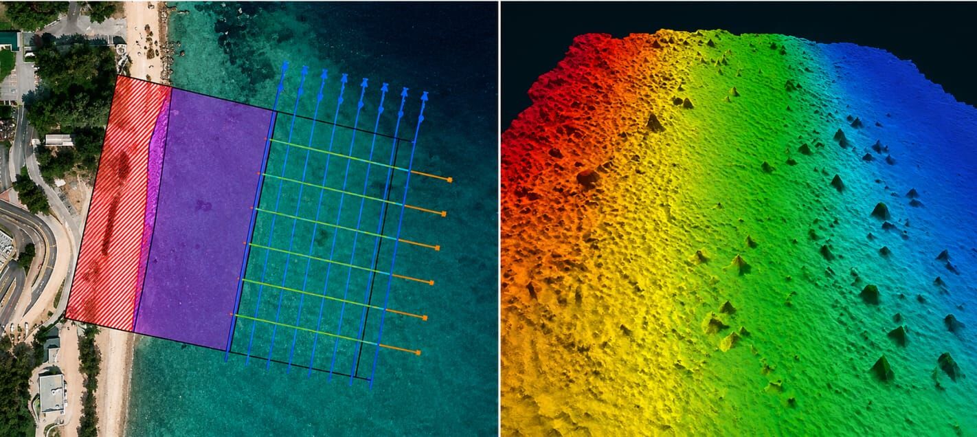
The survey required comprehensive coverage across inshore topographic/bathymetric and offshore bathymetric & magnetometer zones, with the objective of mapping the seabed and identifying potential buried pipelines, cables and ferromagnetic objects in a challenging shallow-water environment. Survey coverage components: Bathymetry (MBES), Magnetometer Lines, Side Scan Sonar, SDB Coverage, and Camera Path.
2. Our Approach & Solution
- Multibeam Bathymetry: Full-coverage MBES data acquired using NORBIT iWBMS multibeam echosounder mounted on the USV.
- Magnetometer Survey: Marine magnetometer towed behind the USV along lines parallel and perpendicular to the shoreline to detect ferromagnetic anomalies and buried utilities.
- Satellite-Derived Bathymetry (SDB): SDB used alongside acoustic data to extend depth coverage and cross-check results across the wider nearshore area.
- Side Scan Sonar: SSS imagery used to characterize the seabed and identify natural features such as rock/coral outcrops and boulders.
- Underwater Camera (GoPro) Inspection: Towed GoPro provided visual ground-truthing of coral, boulders and sand ripple fields across the nearshore zone, supplementing the geophysical data.
- Processing: All datasets were acquired and processed using HYPACK/HYSWEEP, generating validated bathymetric surfaces, magnetometer plots, and seabed classification for engineering review.
3. Technologies & Methodologies
4. Results & Impact:
- Comprehensive Mapping — Multi-sensor data for complete seabed characterization.
- Hazard & Utility Detection — Identified potential subsea hazards and buried utilities.
- Data Confidence — Cross-validation of acoustic, magnetic, satellite and visual datasets.
- Safer & Efficient Operations — USV enabled efficient data collection in shallow, difficult-to-access areas.
- High-Quality Deliverables — Validated outputs supporting engineering and planning decisions.
5. Conclusion
This project demonstrates how USV technology and multi-sensor integration can transform nearshore hydrographic surveying — delivering safer, efficient and comprehensive seabed data for complex shallow-water environments.
Trusted by Industry Leaders
We partner with offshore operators and pipeline companies to deliver precision survey solutions.
Offshore Operations
Major offshore oil and gas operators trust our survey technology for critical infrastructure projects.
Pipeline Companies
Leading pipeline infrastructure companies rely on our precision mapping and underground utility services.
Engineering Firms
Engineering consultancies partner with us for accurate survey data and 3D modeling services.
IMPACT
Timeline
Comprehensive survey results delivered in six weeks.
Deliverables
Topographical drawings, digital terrain models, contour maps, longitudinal profiles, 2D & 3D underground utility maps.
Safety
Avoided potential hazards and optimized pipeline route.
Cost-Efficiency
Achieved significant cost savings and reduced construction time.
Technology
Utilized advanced tools like LiDAR and GPR.
Efficiency
Enhanced data collection and analysis processes.