Success Stories
In-depth insights from our successful projects and the measurable impact we've delivered for our clients
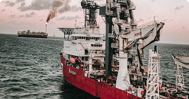
Subsea Carbon Capture Enablement
Comprehensive offshore hydrographic survey services including vessel provision and advanced geophysical survey technologies. Our exacting approach in the North Sea delivered complete site characterization for emerging energy infrastructure with zero environmental impact.
1. Challenge
The transition to sustainable energy required precise subsea site characterization for a pioneering carbon capture project in the challenging North Sea environment. Beyond technical expertise, the scope demanded complete marine operations—vessel provision, specialized equipment, and expert crew capable of operating in environmentally sensitive waters while delivering millimeter-accurate data for critical infrastructure planning.
2. Our Approach & Solution
- Dedicated Survey Vessel: Provided a specialized survey vessel equipped with moonpool and A-frame, optimized for stable sensor deployment in challenging North Sea conditions
- Multi-Technology Geophysical Suite: Deployed dual-head multibeam echosounders, side-scan sonar, and magnetometer arrays for comprehensive seabed characterization
- Environmental Stewardship: Implemented marine mammal observation and passive acoustic monitoring, ensuring zero ecological impact in the sensitive North Sea ecosystem
- Precision Data Processing: Our in-house team applied sophisticated workflows, transforming raw sensor data into actionable intelligence for storage site selection
3. Technologies & Methodologies
4. Results & Impact:
- Complete Turnkey Delivery: Provided 100% of vessel, equipment, and personnel requirements, eliminating client coordination complexity
- Regulatory Compliance: Delivered data meeting all specifications for carbon storage infrastructure approval in the North Sea region
- Environmental Protection: Maintained zero environmental impact throughout operations in sensitive marine ecosystems
- Risk Mitigation: Identified all potential geohazards, enabling safe storage infrastructure design
- Project Acceleration: Provided critical data to advance from concept to implementation phase
5. Conclusion
This North Sea project demonstrates our exacting approach to marine operations, delivering comprehensive solutions that address both technical and operational challenges in demanding environments. By combining vessel provision with advanced surveying expertise, we enabled the safe development of critical sustainable energy infrastructure—demonstrating that precision and environmental stewardship can coexist in service of the energy transition, even in the world's most challenging offshore environments.
Trusted by Industry Leaders
We partner with offshore operators and pipeline companies to deliver precision survey solutions.

Offshore Operations
Major offshore oil and gas operators trust our survey technology for critical infrastructure projects.

Pipeline Companies
Leading pipeline infrastructure companies rely on our precision mapping and underground utility services.

Engineering Firms
Engineering consultancies partner with us for accurate survey data and 3D modeling services.
IMPACT

Timeline
Comprehensive survey results delivered in six weeks.

Deliverables
Topographical drawings, digital terrain models, contour maps, longitudinal profiles, 2D & 3D underground utility maps.

Safety
Avoided potential hazards and optimized pipeline route.

Cost-Efficiency
Achieved significant cost savings and reduced construction time.

Technology
Utilized advanced tools like LiDAR and GPR.

Efficiency
Enhanced data collection and analysis processes.