Connect – Data Integration & Connectivity

Digital twin

We bridge the gap between design and operations through seamless enterprise integration. Our solutions connect digital twins directly with SAP, BIM, and IoT platforms, enabling real-time data flow between engineering systems and field operations.

From Isolated Datasets to One Operational Picture

Our data integration service unifies everything you capture — laser scans, hydrographic and geophysical surveys, AUV/ROV data, GIS layers, SCADA feeds, IoT sensors, satellite imagery, CAD/BIM models, and enterprise asset records — into a single, coherent geospatial intelligence layer that your entire organisation can trust and act on.

No conflicting datums. No format incompatibilities. No information locked inside isolated platforms. One version of the truth — spanning subsea infrastructure, surface facilities, and city-scale assets — from a single, unified environment.

We mobilise rapidly, configure integration pipelines to your existing systems and workflows, and deliver a connected spatial intelligence layer in days — giving your engineering, operations, and asset management teams the dimensional and operational clarity they need from day one.

How We Connect Your Data

Geospatial Normalisation

All incoming datasets — point clouds, bathymetry, sub-bottom profiles, utility maps, drone surveys, satellite imagery, CAD, BIM, and tabular records — are transformed into a common spatial reference framework, unifying land, coastal, marine, and subsurface data into consistent projections and vertical datums. Legacy drawings, survey control networks, and GNSS-based datasets are resolved into a single, traceable geodetic model, with full metadata and transformation logs maintained so every coordinate decision remains auditable years into the future.

Multi Source Data Fusion & Model Integration

TLS, SLAM, mobile LiDAR, aerial LiDAR, and photogrammetric datasets are merged into unified point cloud and surface models, while hydrographic and geophysical products — multibeam bathymetry, sidescan sonar, UXO anomalies, and ground models — are integrated seamlessly with terrestrial topography and underground utility mapping. BIM objects and CAD entities are linked directly to geospatial features, asset IDs, and maintenance records, creating a single, connected environment where every dataset reinforces the next.

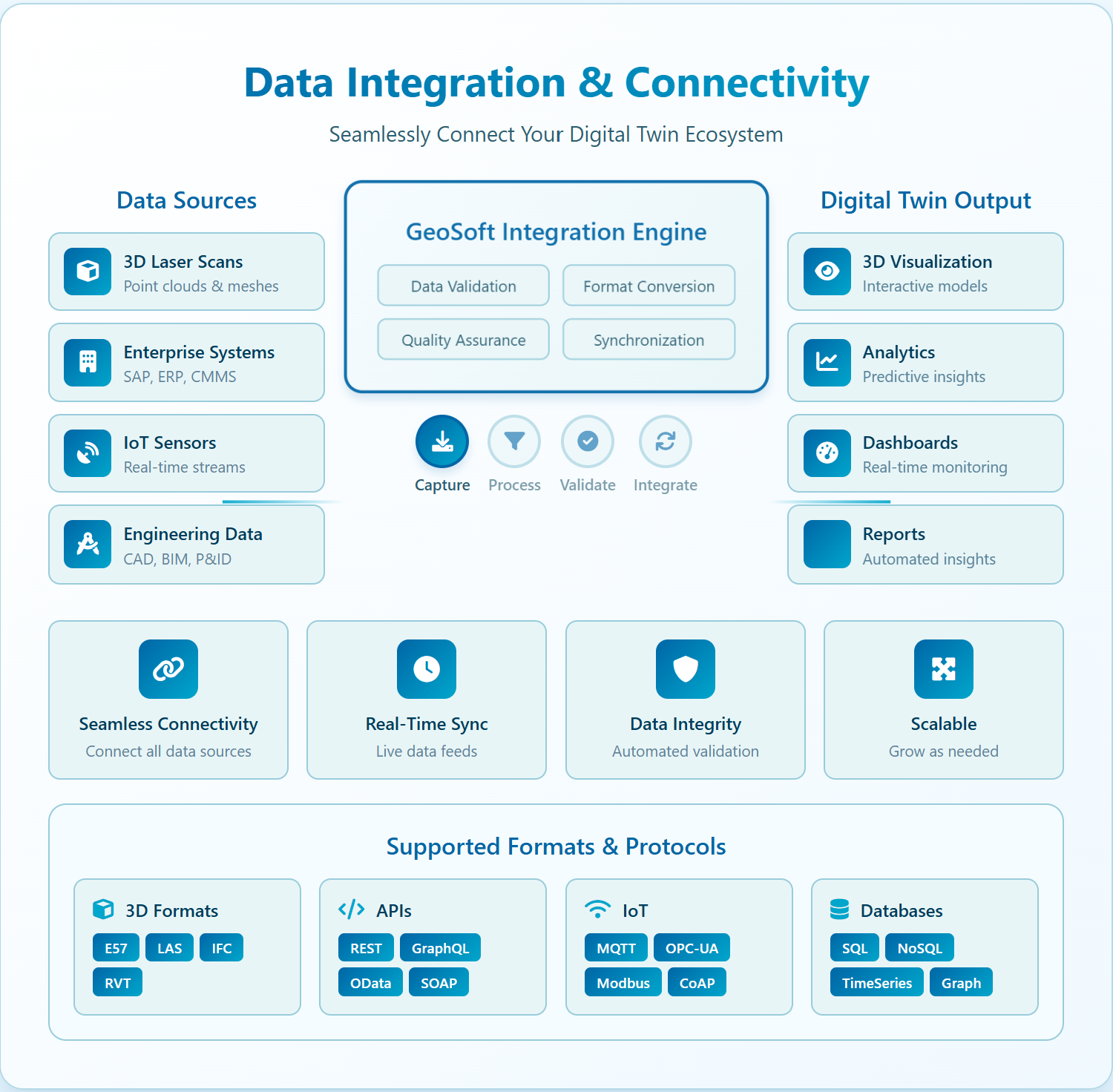
Enterprise System Connectivity & APIs

Connect sits between your technical datasets and enterprise platforms, ensuring data flows directly to where decisions are made. Bidirectional integration with GIS, asset management, EAM, maintenance, ERP, and document management systems keeps every platform current and consistent, while open APIs and data services expose live geospatial layers and 3D models to planning tools, digital twins, web portals, and analytics dashboards in real time.

Real Time Data Streams

Static survey data captures a moment — Connect captures the continuum. Live IoT sensor networks, structural monitors, environmental sensors, and process instrumentation are ingested with full geospatial context, while subsea monitoring feeds, touchdown data, remote ROV video, USV/AUV tracks, and construction telemetry stream directly into the same platform used for design and planning. Time-enabled layers allow users to scroll through the complete spatial and operational history of any asset

What We Deliver: Connected Intelligence

Enterprise Geospatial Data Hub

A secure, central geospatial hub that stores, indexes, and serves all spatial datasets — from subsea surveys and 3D scans to city models and environmental layers.

Deliverables include:

  • Structured enterprise geodatabases and 3D data stores.
  • Catalogued datasets with searchable metadata and access policies.
  • Services for maps, imagery, 3D scenes, and feature layers consumed by other systems.

Integrated 2D/3D Web Portals & Dashboards

Userfriendly web applications that expose complex integrated datasets to nonspecialists.

Deliverables include:

  • 2D/3D web viewers overlaying subsea, surface, and aboveground data in a single interface.
  • Operational dashboards combining KPIs with spatial context (e.g., pipeline condition, UXO status, environmental readings, project progress).
  • Selfservice tools for querying, measuring, exporting, and annotating without specialist desktop software.

Connected Digital Twins & Asset Models

Digital twins that are driven by integrated data, not isolated models.

Deliverables include:

  • Facility, corridor, field, or cityscale twins that blend CAD/BIM, survey, monitoring, and analytics into one interactive environment.
  • Synchronisation pipelines so new surveys, inspections, and sensor data update the twin automatically.
  • Context layers for planning scenarios, “whatif” simulations, and risk/impact assessments.

Integration Blueprints & APIs

Documented integration patterns and technical interfaces ensuring Connect plays cleanly with your existing IT and OT landscape.

Deliverables include:

  • API specifications and data contracts for GIS, EAM/CMMS, ERP, SCADA/telemetry, and document systems.
  • ETL/ELT workflows for bulk migration of legacy spatial data into the hub.
  • Automation scripts and jobs for recurring syncs (e.g., daily asset updates, weekly survey ingests).

Industries We Serve

industry image

deliver image

Oil & Gas

Pipeline Route Survey | Facility Change Detection | Methane Emission Monitoring | | Offshore Platform
Surveillance | Oil Spill Detection | SCADA-GIS Integration I AL/ML based Asset Moniroting

industry  image

industry image

AEC & Building Documentation

Scan-to-BIM Conversion | Construction Progress Monitoring | As-Built Verification | Renovation Design Support |
MEP Coordination

industry  image

deliver image

Infrastructure & Transportation

Traffic flow simulation I Urban Planning | Citizen Service Mapping | Emergency Management | Public Health
Mapping I Rail Network Monitoring | InSAR Settlement Monitoring I Digital twin Development

industry image

deliver image

Mining & Quarrying

Mineral Mapping | Open Pit Volume Monitoring | Tailings Dam Surveillance | Mining Subsidence Monitoring |
Progressive Rehabilitation Tracking | Environmental Compliance Reporting I HSE Virtual Tour

industry  image

industry image

Manufacturing & Industrial

Plant Documentation | Equipment Routing | Maintenance Planning | Digital Twins | Risk Management | VR HSE
Training

industry  image

deliver image

Utilities & Networks

Underground Mapping | Route Planning & Conflict Detection | Asset Documentation | Damage Assessment | Safety
Verification

industry image

deliver image

Coastal, Marine & Hydrographic

Shoreline Change Detection | Satellite Bathymetry | Coastal Erosion Monitoring | Marine Habitat Mapping | Flood
Inundation Modelling | Sediment Transport Analysis

industry  image

industry image

Environmental Management

Environmental Impact Assessment | Habitat Classification | Carbon Accounting | Water Quality Monitoring | Land
Degradation Assessment | Climate Change Indicators | Sustainability Reporting

industry  image

deliver image

Defense, Security & Intelligence

Force Deployment Planning | Terrain Analysis | Border Surveillance Analytics | Geospatial Intelligence (GEOINT)
And Image Intelligence (IMINT)

Our Methodology: Precision at Every Stage

A proven four-stage process ensuring accuracy, compliance, and actionable insights

deliver image

Plan with Intelligence

Before mobilizing, we begin with a data-driven understanding of your asset environment. We perform a comprehensive site intelligence review — analyzing existing drawings, access limitations, hazardous zones, operational constraints, and required accuracy levels.

deliver image

Precision Field Acquisition with real time QC

Our field teams deploy fully calibrated instruments in strict accordance with manufacturer specifications and project QA protocols. Intelligent workflows deliver real-time on-site feedback on coverage, registration integrity, and data quality

deliver image

AI-Driven Data Processing & Extraction

Curates raw data, Guides AI, Validates Output into actionable digital intelligence through a hybrid pipeline of advanced algorithms, machine learning models, and expert review.

deliver image

Decision-Ready Deliverables

Outputs are not merely models but enterprise-ready information assets. All datasets undergo independent quality assurance audits. We ensure your organization can immediately operationalize the data for planning, maintenance, and strategic decision-making.

Case Studies

We're building a greener tomorrow. Our solutions optimize operations, cut waste, and lower emissions, supporting net-zero goals.

Digital twin

Enterprise Digital Transformation for Major NOC

Virtual Eye: Unifying 40 years of fragmented asset data across 700+ platforms for one of the Middle East's largest oil field operators. Our on-premise solution integrated 20+…

700+
Platforms Integrated
20+
Engineering Systems Consolidated
Millions
High-Resolution Imagery Processed
Digital twin

Digital Twin Platform

Experience the future of offshore asset management with our digital twin development services. The Virtual Eye platform eliminates frequent site visits through real-time visual surveillance and AI-powered analytics,

90%
Faster Data Access
100%
ERP Integration
ZERO
Reduced Site Visits
Digital twin

Digital Twin & AI Solutions

Transforming asset management through automated visual recognition and AI-driven data integration. Our computer vision platform eliminates manual tag registration, enabling rapid deployment of operational digital…

95%
Accuracy
80%
Time Reduction
100%
Legacy System Integration

Why Organizations Choose Our Digital twin Services

Technical Excellence

Industry-leading accuracy specifications (±1–2 mm TLS, ±2–5 cm aerial) backed by systematic, documented QA/QC processes ensuring reliable, repeatable results across diverse project types — from offshore platforms in extreme marine environments to sensitive heritage interiors.

Operational Efficiency

Multi-platform deployment and AI-accelerated processing compress project timelines by up to 70%. What once required months of manual survey and CAD drafting now delivers registered, classified point clouds and intelligent models in days to weeks.

Integrated Solutions

Complete service delivery from project planning and field acquisition through processing, modeling, and specialized analysis — all under one roof. No fragmented vendor chains, no data conversion losses, no accountability gaps.

Industry Expertise

25+ years of specialized knowledge across regulated, high-stakes environments. We don’t just capture geometry — we understand what it means for your operations, your compliance obligations, and your capital planning decisions.

Proven ROI

Our clients consistently document measurable returns: 30–50% reduction in field rework, 20–40% faster project delivery, elimination of fabrication mismatches, and extended asset service life through predictive condition monitoring. Reality capture isn’t an expense — it’s a multiplier on every downstream decision.

The Digital twin Intelligence Advantage 

We stand at the intersection of survey engineering precision and digital innovation — transforming raw laser measurements, sensor data, and georeferenced imagery into the spatial intelligence that powers your organisation’s most consequential decisions.

Contact Our Specialist

Get in touch to discuss comprehensive terrestrial and aerial laser scanning addressing your project requirements.


Global Operations
24/7 support across multiple time zones