Engineering Studies & Compliance

Engineering support

Data-driven insights for compliance and sustainability. We offer specialized engineering studies enhanced by our technical expertise and industry knowledge.

One platform. Real geometry. Every training scenario, every field operation, every asset — connected. 

The Virtual Eye Platform is Geosoft Global’s end-to-end immersive intelligence solution — purpose-built for the energy, defence, infrastructure, and marine sectors. It combines facility-accurate virtual environments, high-fidelity emergency and operational training, procedure-based competency assessment, and live augmented reality field support into a single, integrated platform anchored to real survey data.

Where other training systems start with generic 3D models and approximations, Virtual Eye starts with the truth — your asset, captured at centimetre precision, converted into an immersive digital world that reflects exactly what your workforce will encounter on site. it is a living operational intelligence platform. Every deployment produces structured, measurable, and continuously evolving outputs that span training, compliance, predictive maintenance, and real-time asset management.

How We Turn Your Asset Into an Intelligent Digital World

Asset Capture & Digital Foundation

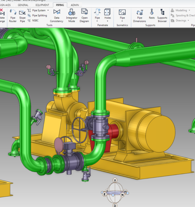
We start where the truth lives — the physical asset. Using terrestrial laser scanning, mobile LiDAR SLAM, drone photogrammetry, and close-range reality capture, we acquire centimetre-accurate point clouds of your facility — reconciled against existing BIM models, CAD drawings, and engineering documentation to build a single verified digital foundation that every Virtual Eye product is built upon.

Environment Build & Scenario Engineering

Captured data is converted into fully navigable, photorealistic virtual environments — populated with accurate equipment, instrumentation, signage, and spatial relationships that match the real facility. HSE scenarios, emergency response sequences, and maintenance procedure trainers are engineered directly into the environment with interactive logic, error detection, and multi-player capability built in from the start.

Sensor Integration & Digital Twin Activation

Live data is mapped onto the virtual environment — IoT sensors, SCADA feeds, inspection records, and operational data streams synchronise the digital twin with the real-time state of the physical asset. Predictive maintenance algorithms are configured, anomaly detection thresholds are set, and operational dashboards are built to surface intelligence where decisions are made.

AR Deployment, Integration & Continuous Update

AR field applications are configured for tablet and headset deployment — populated with live data overlays, work instructions, and inspection records anchored to real asset geometry. Virtual Eye is then connected to your LMS, CMMS, ERP, and asset management systems and handed over with full documentation. Scheduled update cycles keep every environment, procedure trainer, and digital twin aligned with the current as-operated state of your facility — so the platform grows with the asset, not behind it.

What Virtual Eye Delivers

Digital twin with live asset synchronisation

A continuously updated, data-rich digital replica of your asset that ingests real-time feeds from IoT sensors, inspection records, and operational systems — reflecting the true current state of the physical asset at any moment, not a static snapshot from commissioning.

HSE & Emergency Response Training

High-consequence, low-frequency scenarios that cannot safely be rehearsed on live assets are where Virtual Eye delivers its highest value. Hydrocarbon releases, fires, explosions, confined space emergencies, man-overboard events, and structural failures are simulated inside your actual facility geometry — training emergency response teams on real muster routes, evacuation paths, and firefighting positions.

Predictive maintenance intelligence 

Sensor feeds from monitored assets are mapped onto the digital twin in real time, enabling condition-based maintenance triggers, anomaly detection, and remaining-useful-life projections that shift maintenance from scheduled intervals to actual asset condition — reducing unplanned downtime and unnecessary intervention costs.

Platform integration package 

Configured data connectors linking Virtual Eye to your existing enterprise ecosystem — LMS, CMMS, ERP, SCADA, asset management platforms, and operational control systems — so intelligence flows where decisions are made.

Industries We Serve

industry image

deliver image

Oil & Gas

Pipeline Route Survey | Facility Change Detection | Methane Emission Monitoring | | Offshore Platform
Surveillance | Oil Spill Detection | SCADA-GIS Integration I AL/ML based Asset Moniroting

industry  image

industry image

AEC & Building Documentation

Scan-to-BIM Conversion | Construction Progress Monitoring | As-Built Verification | Renovation Design Support |
MEP Coordination

industry  image

deliver image

Infrastructure & Transportation

Traffic flow simulation I Urban Planning | Citizen Service Mapping | Emergency Management | Public Health
Mapping I Rail Network Monitoring | InSAR Settlement Monitoring I Digital twin Development

industry image

deliver image

Mining & Quarrying

Mineral Mapping | Open Pit Volume Monitoring | Tailings Dam Surveillance | Mining Subsidence Monitoring |
Progressive Rehabilitation Tracking | Environmental Compliance Reporting I HSE Virtual Tour

industry  image

industry image

Manufacturing & Industrial

Plant Documentation | Equipment Routing | Maintenance Planning | Digital Twins | Risk Management | VR HSE
Training

industry  image

deliver image

Utilities & Networks

Underground Mapping | Route Planning & Conflict Detection | Asset Documentation | Damage Assessment | Safety
Verification

industry image

deliver image

Coastal, Marine & Hydrographic

Shoreline Change Detection | Satellite Bathymetry | Coastal Erosion Monitoring | Marine Habitat Mapping | Flood
Inundation Modelling | Sediment Transport Analysis

industry  image

industry image

Environmental Management

Environmental Impact Assessment | Habitat Classification | Carbon Accounting | Water Quality Monitoring | Land
Degradation Assessment | Climate Change Indicators | Sustainability Reporting

industry  image

deliver image

Defense, Security & Intelligence

Force Deployment Planning | Terrain Analysis | Border Surveillance Analytics | Geospatial Intelligence (GEOINT)
And Image Intelligence (IMINT)

Our Methodology: Precision at Every Stage

A proven four-stage process ensuring accuracy, compliance, and actionable insights

deliver image

Plan with Intelligence

Before mobilizing, we begin with a data-driven understanding of your asset environment. We perform a comprehensive site intelligence review — analyzing existing drawings, access limitations, hazardous zones, operational constraints, and required accuracy levels.

deliver image

Precision Field Acquisition with real time QC

Our field teams deploy fully calibrated instruments in strict accordance with manufacturer specifications and project QA protocols. Intelligent workflows deliver real-time on-site feedback on coverage, registration integrity, and data quality

deliver image

AI-Driven Data Processing & Extraction

Curates raw data, Guides AI, Validates Output into actionable digital intelligence through a hybrid pipeline of advanced algorithms, machine learning models, and expert review.

deliver image

Decision-Ready Deliverables

Outputs are not merely models but enterprise-ready information assets. All datasets undergo independent quality assurance audits. We ensure your organization can immediately operationalize the data for planning, maintenance, and strategic decision-making.

Case Studies

We're building a greener tomorrow. Our solutions optimize operations, cut waste, and lower emissions, supporting net-zero goals.

Engineering support

Zero Downtime Equipment Replacement

Transforming shutdown planning through advanced 3D laser scanning and precision modeling. Our team's engineering innovation approach enabled the replacement of 2,000+ spools with zero dimensional…

2,000+
Spools Replaced
100%
Fit-Up Accuracy
Zero
Offshore Rework
Engineering support

Logistic Route Optimization Survey

Transforming offshore plant logistics through advanced SLAM technology and 3D mapping. Our team's rapid route analysis identified optimal pathways for heavy equipment transport, reducing planning…

M-W
Planning Time Reduction
100%
Obstruction Identification
Zero
Transportation Delays

Why Organizations Choose Our Digital twin Services

Technical Excellence

Industry-leading accuracy specifications (±1–2 mm TLS, ±2–5 cm aerial) backed by systematic, documented QA/QC processes ensuring reliable, repeatable results across diverse project types — from offshore platforms in extreme marine environments to sensitive heritage interiors.

Operational Efficiency

Multi-platform deployment and AI-accelerated processing compress project timelines by up to 70%. What once required months of manual survey and CAD drafting now delivers registered, classified point clouds and intelligent models in days to weeks.

Integrated Solutions

Complete service delivery from project planning and field acquisition through processing, modeling, and specialized analysis — all under one roof. No fragmented vendor chains, no data conversion losses, no accountability gaps.

Industry Expertise

25+ years of specialized knowledge across regulated, high-stakes environments. We don’t just capture geometry — we understand what it means for your operations, your compliance obligations, and your capital planning decisions.

Proven ROI

Our clients consistently document measurable returns: 30–50% reduction in field rework, 20–40% faster project delivery, elimination of fabrication mismatches, and extended asset service life through predictive condition monitoring. Reality capture isn’t an expense — it’s a multiplier on every downstream decision.

The Spatial Intelligence Advantage

The geospatial industry is undergoing a fundamental transformation. AI-powered point cloud classification, real-time SLAM navigation, and cloud-based digital twin platforms are converging to make reality capture faster, more accessible, and more valuable than ever before.

Contact Our Specialist

Get in touch to discuss comprehensive terrestrial and aerial laser scanning addressing your project requirements.


Global Operations
24/7 support across multiple time zones