Marine Habitat Mapping

Subsea services

We deliver marine habitat mapping and biodiversity assessment using multibeam sonar, eDNA sampling, and benthic habitat classification. Our environmental compliance services provide the definitive data required for regulatory approvals and sustainable project planning.

From Acoustic Signatures to Ecological Maps

Our marine habitat mapping services translate multibeam bathymetry, acoustic backscatter intensity, and optical imagery into spatially explicit, classification-ready maps of seabed substrates, benthic habitats, and biotopes — resolving the distribution of sand, mud, gravel, rock, biogenic reef, seagrass meadows, and cold-water coral across project areas of any scale or complexity.

We deploy high-resolution multibeam echo sounders calibrated for backscatter acquisition alongside machine-learning classification workflows and standardised habitat schemes to produce quantitative, repeatable habitat maps that meet the evidentiary standards required by environmental regulators, statutory consultees, and international marine protected area management bodies. What we deliver is not raw acoustic data — it is decision-ready environmental intelligence.

How We Map Marine Habitats

Multibeam Bathymetry & Backscatter Acquisition

Highresolution multibeam systems collect coregistered bathymetry and backscatter, capturing both seabed morphology and acoustic response at metre to submetrescale resolution. Postprocessing corrects for motion, water column, and radiometric effects to produce terrain models and mosaicked backscatter that reflect true seabed texture and roughness.

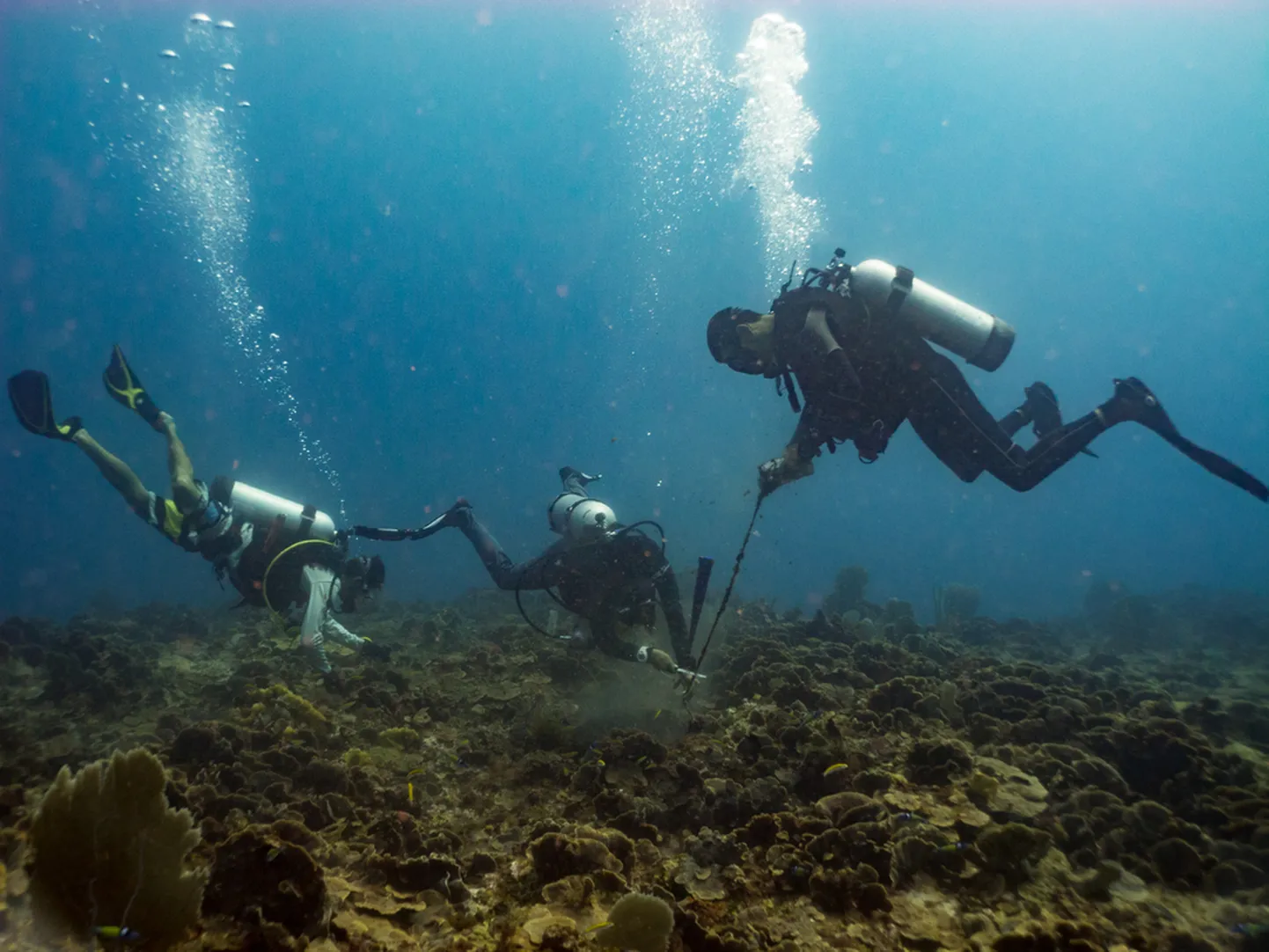
GroundTruthing with Video & Samples

Targeted video/stills transects and physical samples (grabs, cores) provide direct evidence of substrate, fauna, and habitat types at representative locations. These observations are linked to acoustic signatures to train and validate classification models, ensuring that mapped classes correspond to real seabed conditions.

Supervised Classification & Standardised Schemes

Bathymetric derivatives (slope, rugosity, curvature) and backscatter metrics are combined with groundtruth data in supervised machinelearning workflows such as Random Forests to predict habitat classes across the full survey area. Outputs are organised according to recognised frameworks (e.g., EUNIS or national habitat schemes) so they can be directly used in EIAs, conservation planning, and regulatory submissions.

StakeholderAligned Mapping for EIA & Marine Planning

Habitat mapping workflows are aligned with the needs of environmental regulators, marine spatial planners and other stakeholders from the outset, ensuring outputs are directly usable in EIAs, marine protected area design, and spatial planning decisions. Scientific datasets are integrated with local ecological knowledge and sea use information gathered through structured stakeholder engagement, so resulting maps reflect both measured habitats and how they are used by communities and industries.

What We Deliver: Evidence Based Seabed Ecology

Habitat & Substrate Maps

Spatially continuous maps showing the distribution of key habitat and substrate classes (e.g., sand, mud, gravel, rock, reef, seagrass, coral assemblages) at project appropriate resolutions. Each class is supported by representative imagery and metadata describing confidence levels and underlying acoustic/terrain characteristics.

Geomorphology & Benthic Terrain Products

Derived layers describing seabed morphology—such as slopes, banks, channels, bedforms, escarpments, and reef structures—that control habitat patterns and ecological function. These products support route engineering, micrositing of foundations and cables, and the identification of areas prone to scour or sediment mobility.

Baseline, Sensitivity & Change Detection Layers

Baseline habitat and substrate datasets structured to support impact assessment, zoning of ecological sensitivity, and longterm monitoring of changes due to projects or natural processes. Repeated surveys can be compared to quantify shifts in habitat extent, condition, and community composition over time.

GIS & Regulatory Ready Deliverables

All outputs are delivered as GIS ready rasters and vectors, accompanied by classification keys, confidence maps, and documentation suitable for integration into EIA studies, MPA management plans, and marine spatial planning tools. This ensures environmental teams, engineers, and regulators work from a common, defensible view of the seabed’s ecological fabric when making siting, routing, and mitigation decisions.

Industries We Serve

industry image

deliver image

Oil, Gas & Renewables

Platform Site Surveys | Pipeline Route Surveys | Offshore Wind Foundation Zones | Cable Landing Corridors | Scour Monitoring | Free-Span Detection

industry  image

industry image

Ports & Harbours

Nautical Charting | Approach Channel Surveys | Berth Pocket Mapping | Turning Circle Verification | Under-Keel Clearance Analysis | Dredge Volume Computation

industry  image

deliver image

Coastal Engineering & Climate Resilience

Shoreline Change Mapping | Beach Profile Surveys | Nearshore Morphology | Storm Impact Assessment | Breakwater Design | Coastal Defence Monitoring

industry image

deliver image

Dredging & Marine Construction

Pre/Post-Dredge Surveys | Pay-Volume Certification | Rock Placement Verification | Construction Tolerance Checks | As-Built Documentation | Material Classification

industry  image

industry image

Marine Infrastructure

Bridge Pier Scour Assessment | Causeway Alignment Surveys | Submerged Asset Inspection | Intake/Outfall Mapping | Quay Wall Condition Assessment

industry  image

deliver image

Water Resources & Inland Hydraulics

Reservoir & Dam Surveys | River Cross-Sections | Floodplain Bathymetry | Sedimentation Studies | Hydrodynamic Model Inputs

industry image

deliver image

Marine Mining

Seabed Mineral Exploration | Deep‑Ocean Resource Mapping | AUV Survey | Multiphysics Targeting | Environmental Baseline

industry  image

industry image

Environmental Management

Benthic Habitat Mapping | Seagrass & Reef Extent | Sediment Dynamics | Dredge Plume Tracking | Marine Protected Area Baseline | Change Monitoring

industry  image

deliver image

Defence & Security

Seabed Clearance | UXO Pre-Characterization | Submerged Obstruction Detection | Underwater Infrastructure Mapping | Risk & Vulnerability Assessment

Our Methodology: Precision at Every Stage

A proven four-stage process ensuring accuracy, compliance, and actionable insights

deliver image

Plan with Intelligence

Before mobilizing, we begin with a data-driven understanding of your asset environment. We perform a comprehensive site intelligence review — analyzing existing drawings, access limitations, hazardous zones, operational constraints, and required accuracy levels.

deliver image

Precision Field Acquisition with real time QC

Our field teams deploy fully calibrated instruments in strict accordance with manufacturer specifications and project QA protocols. Intelligent workflows deliver real-time on-site feedback on coverage, registration integrity, and data quality

deliver image

AI-Driven Data Processing & Extraction

Curates raw data, Guides AI, Validates Output into actionable digital intelligence through a hybrid pipeline of advanced algorithms, machine learning models, and expert review.

deliver image

Decision-Ready Deliverables

Outputs are not merely models but enterprise-ready information assets. All datasets undergo independent quality assurance audits. We ensure your organization can immediately operationalize the data for planning, maintenance, and strategic decision-making.

Case Studies

We're building a greener tomorrow. Our solutions optimize operations, cut waste, and lower emissions, supporting net-zero goals.

Subsea services

Subsea Geophysical Services

Advanced nearshore pipeline mapping using integrated geophysical technologies to determine precise burial status and mitigate environmental risks. Our comprehensive survey delivers the critical data needed…

200m
Survey Corridor Width
100%
Data Compliance
Zero
Environmental Incidents
Subsea services

Precision Positioning & Metrology

Millimeter-accurate jacket positioning using robotic total stations and high-precision leveling to ensure perfect fit-up between new and existing structures. Our exacting survey methodology delivered flawless…

±2mm
Positioning Accurac
100%
Fit-Up Accuracy
Zero
Safety Incidents

Why Organizations Choose Our Marine Habitat Mapping Services

Technical Excellence

Industry-leading accuracy specifications (±1–2 mm TLS, ±2–5 cm aerial) backed by systematic, documented QA/QC processes ensuring reliable, repeatable results across diverse project types — from offshore platforms in extreme marine environments to sensitive heritage interiors.

Operational Efficiency

Multi-platform deployment and AI-accelerated processing compress project timelines by up to 70%. What once required months of manual survey and CAD drafting now delivers registered, classified point clouds and intelligent models in days to weeks.

Integrated Solutions

Complete service delivery from project planning and field acquisition through processing, modeling, and specialized analysis — all under one roof. No fragmented vendor chains, no data conversion losses, no accountability gaps.

Industry Expertise

25+ years of specialized knowledge across regulated, high-stakes environments. We don’t just capture geometry — we understand what it means for your operations, your compliance obligations, and your capital planning decisions.

Proven ROI

Our clients consistently document measurable returns: 30–50% reduction in field rework, 20–40% faster project delivery, elimination of fabrication mismatches, and extended asset service life through predictive condition monitoring. Reality capture isn’t an expense — it’s a multiplier on every downstream decision.

The Subsea Intelligence Advantage

At the intersection of marine survey rigour and advanced digital workflows, we transform raw acoustic and optical signals into validated, fully integrated subsea models that engineering, dredging, and operations teams can interrogate, trust, and act on from day one.

Contact Our Specialist

Get in touch to discuss comprehensive terrestrial and aerial laser scanning addressing your project requirements.


Global Operations
24/7 support across multiple time zones