Visualize – Advanced Visualization & Dashboards

Digital twin

We transform complex engineering data into intuitive web-based dashboards and 3D visualization platforms. Our solutions provide real-time asset performance monitoring and operational intelligence through accessible, user-friendly interfaces.

From Data Repositories to Decisions at a Glance

Our advanced visualisation service transforms point clouds, bathymetric models, subsurface geology, environmental readings, asset conditions, and operational KPIs into immersive 3D environments, live dashboards, and interactive spatial applications that engineering, operations, management, and field teams can interrogate and act on directly — without specialist desktop software, data science expertise, or technical intermediaries.

Data that cannot be understood cannot be acted on. Every dataset captured, integrated, and monitored across your asset lifecycle deserves to be seen clearly — and seen by the right people, at the right level of detail, at the right moment. We take the complete output of Capture, Survey, Connect, and Monitor and turn it into spatial intelligence that drives planning, maintenance, compliance, and investment decisions at every level of your organisation.

We deploy rapidly, configure visualisation environments to your workflows and platforms, and deliver decision-ready spatial interfaces in days — so your teams spend less time interpreting data and more time acting on it.

How We Visualize Your World

Immersive 3D Scene & Point Cloud Viewing

Complex geometric environments — refineries, offshore platforms, harbour basins, city blocks, underground voids — rendered as navigable 3D scenes accessible from standard browsers and tablets. Stream billion‑point clouds and textured 3D meshes using Cesium, 3D Tiles, and I3S without desktop software installation. Navigate, measure, annotate, and compare scan data with photogrammetry, BIM models, and GIS layers in a single unified scene.

Live Operational Dashboards

Real-time dashboards that fuse spatial data with operational parameters, delivering situational awareness across facilities, corridors, and marine environments. Role-specific dashboards for operations, HSE, asset integrity, and executive teams — each showing the right information at the right level of detail. Configurable KPI tiles, trend charts, and threshold alerts for structural monitoring, environmental compliance, production, and safety parameters.

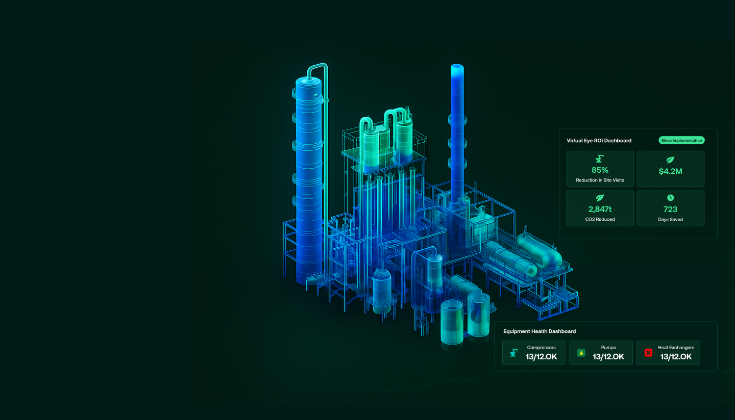
Digital Twin Visualization Environments

Interactive digital twin platforms that fuse geometric accuracy with live data, creating a continuously updated virtual replica of your asset, facility, or project.
Synchronise TLS/aerial scan geometry, BIM models, and MBES bathymetry into a single twin that updates as new surveys, sensor readings, and inspection records arrive. Overlay IoT streams, SCADA values, and environmental monitoring data directly onto the 3D model — visualizing process conditions at their physical location in the asset.

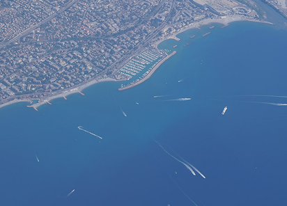
Web GIS Portals & Public-Facing Applications

We deliver scalable web mapping applications that make complex geospatial intelligence accessible to every stakeholder — from technical engineers to senior decision-makers — without requiring GIS expertise, desktop software, or reliance on your data team. We configure multi-layer web maps combining hydrographic surveys, utility networks, habitat maps, land use, infrastructure, and environmental data into secure, intuitive portals that are purpose-built around your organisation’s workflows, access requirements, and reporting obligations.

What We Deliver: Visual Intelligence Assets

Web-Based 3D Viewers & Scene Applications

Fully hosted or client-deployable 3D web applications that stream point clouds, meshes, BIM models, and geospatial layers directly to any browser. Every deployment includes configured 3D scene environments with measurement, annotation, and layer management capabilities, complete user administration, access control, and usage analytics, alongside embed-ready widgets that integrate seamlessly into your existing client portals and intranets.

Digital Twin Platforms

End-to-End digital twin visualisation environments that integrate geometry, live sensor data, and operational feeds across facilities, pipeline corridors, marine assets, and city-scale environments. Every environment is configured with synchronised data pipelines, sensor overlays, and scenario modelling tools, with integration connectors built for SCADA, IoT, EAM/CMMS, and GIS platforms.

Web GIS Portals

Scalable multi-layer GIS portals and narrative mapping products built for both professional and public audiences — from technical project teams to regulatory authorities and community stakeholders. Configured ArcGIS, QGIS, and open-source web GIS portals are deployed with managed datasets, structured user access tiers, and maintained spatial libraries that stay current as your project evolves.

AR/VR Experiences & Training Environments

Immersive spatial applications that turn your captured environments into powerful tools for training, inspection, and stakeholder engagement — going far beyond static models to create experiences your teams and stakeholders can step inside and interact with. VR walkthroughs of offshore facilities, industrial plants, and heritage sites give remote teams, clients, and decision-makers a precise, navigable sense of place without requiring physical access.

Industries We Serve

industry image

deliver image

Oil & Gas

Pipeline Route Survey | Facility Change Detection | Methane Emission Monitoring | | Offshore Platform
Surveillance | Oil Spill Detection | SCADA-GIS Integration I AL/ML based Asset Moniroting

industry  image

industry image

AEC & Building Documentation

Scan-to-BIM Conversion | Construction Progress Monitoring | As-Built Verification | Renovation Design Support |
MEP Coordination

industry  image

deliver image

Infrastructure & Transportation

Traffic flow simulation I Urban Planning | Citizen Service Mapping | Emergency Management | Public Health
Mapping I Rail Network Monitoring | InSAR Settlement Monitoring I Digital twin Development

industry image

deliver image

Mining & Quarrying

Mineral Mapping | Open Pit Volume Monitoring | Tailings Dam Surveillance | Mining Subsidence Monitoring |
Progressive Rehabilitation Tracking | Environmental Compliance Reporting I HSE Virtual Tour

industry  image

industry image

Manufacturing & Industrial

Plant Documentation | Equipment Routing | Maintenance Planning | Digital Twins | Risk Management | VR HSE
Training

industry  image

deliver image

Utilities & Networks

Underground Mapping | Route Planning & Conflict Detection | Asset Documentation | Damage Assessment | Safety
Verification

industry image

deliver image

Coastal, Marine & Hydrographic

Shoreline Change Detection | Satellite Bathymetry | Coastal Erosion Monitoring | Marine Habitat Mapping | Flood
Inundation Modelling | Sediment Transport Analysis

industry  image

industry image

Environmental Management

Environmental Impact Assessment | Habitat Classification | Carbon Accounting | Water Quality Monitoring | Land
Degradation Assessment | Climate Change Indicators | Sustainability Reporting

industry  image

deliver image

Defense, Security & Intelligence

Force Deployment Planning | Terrain Analysis | Border Surveillance Analytics | Geospatial Intelligence (GEOINT)
And Image Intelligence (IMINT)

Our Methodology: Precision at Every Stage

A proven four-stage process ensuring accuracy, compliance, and actionable insights

deliver image

Plan with Intelligence

Before mobilizing, we begin with a data-driven understanding of your asset environment. We perform a comprehensive site intelligence review — analyzing existing drawings, access limitations, hazardous zones, operational constraints, and required accuracy levels.

deliver image

Precision Field Acquisition with real time QC

Our field teams deploy fully calibrated instruments in strict accordance with manufacturer specifications and project QA protocols. Intelligent workflows deliver real-time on-site feedback on coverage, registration integrity, and data quality

deliver image

AI-Driven Data Processing & Extraction

Curates raw data, Guides AI, Validates Output into actionable digital intelligence through a hybrid pipeline of advanced algorithms, machine learning models, and expert review.

deliver image

Decision-Ready Deliverables

Outputs are not merely models but enterprise-ready information assets. All datasets undergo independent quality assurance audits. We ensure your organization can immediately operationalize the data for planning, maintenance, and strategic decision-making.

Case Studies

We're building a greener tomorrow. Our solutions optimize operations, cut waste, and lower emissions, supporting net-zero goals.

Digital twin

Enterprise Digital Transformation for Major NOC

Virtual Eye: Unifying 40 years of fragmented asset data across 700+ platforms for one of the Middle East's largest oil field operators. Our on-premise solution integrated 20+…

700+
Platforms Integrated
20+
Engineering Systems Consolidated
Millions
High-Resolution Imagery Processed
Digital twin

Digital Twin Platform

Experience the future of offshore asset management with our digital twin development services. The Virtual Eye platform eliminates frequent site visits through real-time visual surveillance and AI-powered analytics,

90%
Faster Data Access
100%
ERP Integration
ZERO
Reduced Site Visits
Digital twin

Digital Twin & AI Solutions

Transforming asset management through automated visual recognition and AI-driven data integration. Our computer vision platform eliminates manual tag registration, enabling rapid deployment of operational digital…

95%
Accuracy
80%
Time Reduction
100%
Legacy System Integration

Why Organizations Choose Our Digital twin Services

Technical Excellence

Industry-leading accuracy specifications (±1–2 mm TLS, ±2–5 cm aerial) backed by systematic, documented QA/QC processes ensuring reliable, repeatable results across diverse project types — from offshore platforms in extreme marine environments to sensitive heritage interiors.

Operational Efficiency

Multi-platform deployment and AI-accelerated processing compress project timelines by up to 70%. What once required months of manual survey and CAD drafting now delivers registered, classified point clouds and intelligent models in days to weeks.

Integrated Solutions

Complete service delivery from project planning and field acquisition through processing, modeling, and specialized analysis — all under one roof. No fragmented vendor chains, no data conversion losses, no accountability gaps.

Industry Expertise

25+ years of specialized knowledge across regulated, high-stakes environments. We don’t just capture geometry — we understand what it means for your operations, your compliance obligations, and your capital planning decisions.

Proven ROI

Our clients consistently document measurable returns: 30–50% reduction in field rework, 20–40% faster project delivery, elimination of fabrication mismatches, and extended asset service life through predictive condition monitoring. Reality capture isn’t an expense — it’s a multiplier on every downstream decision.

The Digital twin Intelligence Advantage 

We stand at the intersection of survey engineering precision and digital innovation — transforming raw laser measurements, sensor data, and georeferenced imagery into the spatial intelligence that powers your organisation’s most consequential decisions.

Contact Our Specialist

Get in touch to discuss comprehensive terrestrial and aerial laser scanning addressing your project requirements.


Global Operations
24/7 support across multiple time zones