
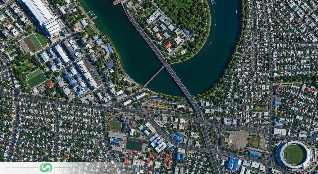
Satellite Imagery & Feature Extraction

Geospatial services

We convert very-high-resolution satellite imagery into structured, GIS-ready feature data. Our AI-driven extraction delivers building footprints, road networks, asset inventories and land cover classification with documented accuracy — across areas ground survey could never economically reach.

From Raw Pixels to Mapped Assets – Structured Feature Intelligence

We deliver professional satellite imagery and feature extraction services that convert multi-source Earth observation data into structured, decision-ready geospatial datasets. Our integrated extraction capabilities — deep learning object detection, semantic segmentation, object-based image analysis, multi-temporal change detection, and expert photo-interpretation – enable organizations to inventory, monitor, and manage assets across areas that ground survey could never economically reach.

Our AI-driven feature extraction and image analysis services deliver building footprints, road and rail networks, asset and object inventories, land use and land cover classification, vegetation and water feature layers, and encroachment and change detection – supplied as topologically clean, attributed vector data across project areas spanning hectares to entire nations.

From a single extraction to a continuous monitoring programme, we provide the structured feature intelligence your organisation needs – matched to your schema, validated against source imagery, and accompanied by the accuracy statistics that make it defensible.

How We Extract Feature Intelligence

A hybrid pipeline — sensor fusion, AI at scale, and expert interpretation — producing data that is both fast and defensible.

Multi-Source Imagery Fusion & Conditioning

Feature extraction is only as reliable as the imagery beneath it. We fuse very-high-resolution optical, multispectral, radar, and archive imagery into a single conditioned environment — radiometrically calibrated, atmospherically corrected, orthorectified, and co-registered to sub-pixel alignment. This gives every extracted feature a consistent geometric and spectral foundation, so results from different dates, sensors, and seasons remain directly comparable.

Deep Learning Detection & Segmentation

Custom-trained convolutional and transformer-based models perform first-pass extraction at scale. U-Net and Mask R-CNN architectures delineate buildings, roads, water bodies, and vegetation, while object detection networks count and locate discrete assets such as tanks, towers, wellheads, vessels, and solar arrays. Models are trained on regional imagery conditions — desert albedo, dust, haze, and dense urban shadow — where generic models underperform.

Expert Validation & Topological Cleaning

Automation supplies throughput; interpretation supplies the standard. Every automated output is reviewed by trained photo-interpreters against source imagery, with ambiguous features escalated rather than guessed. Geometry is then cleaned for gaps, slivers, overshoots, and duplicates, attributes enriched, and completeness and correctness scored against a manually mapped reference sample before anything is released.

Schema-Matched Delivery & Integration

An extraction that will not load cleanly has not been delivered. We match your attribute schema, domain values, coding standards, and coordinate reference system, then deliver as file geodatabase, GeoPackage, GeoJSON, or a direct load into PostGIS or your enterprise geodatabase. Recurring programmes publish through OGC web services and APIs with configurable change alerting.

What We Deliver: From Imagery to Intelligence

BUILDING FOOTPRINT & STRUCTURE DATASETS

Topologically clean building polygons attributed with area, height where stereo or shadow analysis permits, roof type, construction status, and change flags. Supports cadastral and property tax base map enrichment, unpermitted construction detection, informal settlement mapping, population estimation inputs, and disaster exposure modelling.

ROAD, RAIL & NETWORK EXTRACTION

Road and rail centrelines and edges classified by type, surface, and width, plus track, trail, and haul road networks in areas with no existing mapping. Delivered as routable, topologically connected network datasets with junction handling – supporting logistics planning, emergency access analysis, and base map updating.

ASSET & OBJECT DETECTION INVENTORIES

Counted, located, and attributed object inventories extracted at scale: storage tanks with diameter and estimated capacity, transmission towers and poles, wellheads and pads, solar arrays, wind turbines, vessels, vehicles, and stockpiles. Delivered as point or polygon inventories with detection confidence, ready to reconcile against your asset register.

LAND USE & LAND COVER CLASSIFICATION MAPS

Machine learning-classified land cover, land use, crop type, impervious surface, and habitat maps in GIS-ready vector (Shapefile, GeoPackage, GeoJSON) and raster (GeoTIFF) formats. All classifications include accuracy assessment documentation with confusion matrices, kappa coefficients, and per-class accuracy statistics.

CHANGE DETECTION & ENCROACHMENT MONITORING

Feature-level change rather than pixel-level noise — new construction, demolition, right-of-way encroachment, land cover conversion, vegetation loss, and unauthorised development. Each change record carries date bounds, confidence score, quantified area, and before-and-after imagery chips so findings can be verified before action.

GIS DATABASES, WEB SERVICES & CUSTOM AI MODELS

All deliverables packaged in OGC-compliant interoperable formats with ISO 19115 metadata, plus WMS/WMTS/WFS services and interactive browser-based viewers. Where volumes justify it, we also hand over the capability itself: annotated training data, custom-trained models, and inference pipelines deployed in your environment.

Industries We Serve

industry image

deliver image

Oil & Gas

Pipeline Route Survey | Facility Change Detection | Methane Emission Monitoring | | Offshore Platform Surveillance | Oil Spill Detection | SCADA-GIS Integration | AI/ML based Asset Monitoring

industry image

industry image

AEC & Building Documentation

Scan-to-BIM Conversion | Construction Progress Monitoring | As-Built Verification | Renovation Design Support | MEP Coordination

industry image

deliver image

Infrastructure & Transportation

Traffic flow simulation | Urban Planning | Citizen Service Mapping | Emergency Management | Public Health Mapping | Rail Network Monitoring | InSAR Settlement Monitoring | Digital twin Development

industry image

deliver image

Mining & Quarrying

Mineral Mapping | Open Pit Volume Monitoring | Tailings Dam Surveillance | Mining Subsidence Monitoring | Progressive Rehabilitation Tracking | Environmental Compliance Reporting | HSE Virtual Tour

industry image

industry image

Manufacturing & Industrial

Plant Documentation | Equipment Routing | Maintenance Planning | Digital Twins | Risk Management | VR HSE Training

industry image

deliver image

Utilities & Networks

Underground Mapping | Route Planning & Conflict Detection | Asset Documentation | Damage Assessment | Safety Verification

industry image

deliver image

Coastal, Marine & Hydrographic

Shoreline Change Detection | Satellite Bathymetry | Coastal Erosion Monitoring | Marine Habitat Mapping | Flood Inundation Modelling | Shallow Water Analysis

industry image

industry image

Environmental Management

Environmental Impact Assessment | Habitat Mapping | Carbon Accounting | Water Quality Monitoring | Land Degradation Assessment | Climate Change Indicators | Sustainability Reporting

industry image

deliver image

Defense, Security & Intelligence

Force Deployment Planning | Terrain Analysis | Border Surveillance Analytics | Geospatial Intelligence (GEOINT) and Image Intelligence (IMINT)

Our Methodology: Precision at Every Stage

A proven four-stage process ensuring accuracy, compliance, and actionable insights

deliver image

Define the Feature

Before any imagery is ordered, we define the target feature classes, minimum mapping unit, required positional and thematic accuracy, attribute schema, update frequency, and downstream system of record — so acquisition is driven by the decision, not by what a vendor holds in stock.

deliver image

Source, Screen & Condition Imagery

We task new collections or mine archives across commercial and public catalogues, screening every candidate scene for cloud, off-nadir angle, sun elevation, and radiometric quality before it enters the pipeline. Accepted scenes are calibrated, orthorectified, and co-registered to a common reference.

deliver image

AI-Driven Extraction & Expert Validation

Curates imagery, guides AI, validates output. Detection and segmentation models extract at scale; trained photo-interpreters review every result against source imagery, resolve ambiguity, correct topology, and enrich attributes through a hybrid pipeline of advanced algorithms and expert review.

deliver image

Decision-Ready Deliverables

Outputs are not merely layers but enterprise-ready information assets. All datasets undergo independent quality assurance audit with confusion matrices and positional RMSE reported. We ensure your organization can immediately operationalize the data for planning, compliance, and strategic decision-making.

Geospatial Case Studies

We’re building a greener tomorrow. Our solutions optimize operations, cut waste, and lower emissions, supporting net-zero goals. Internally, we use renewable energy, reduce travel with digital tools, and partner with eco-conscious suppliers.

Geospatial services

Geotechnical Investigation Services

Navigating complex border regulations and remote logistics to deliver critical foundation design parameters. Our exacting approach in challenging border regions demonstrates global capability grounded in…

52
Boreholes Completed
100%
Regulatory Compliance
25m
Maximum Investigation Depth
Geospatial services

Precision Geodetic Monitoring

Millimeter-accurate subsidence monitoring across 35 offshore platforms using advanced GNSS technology and international reference frames. Our exacting survey approach achieved sub-centimeter precision over 100km baselines…

±3mm
Positioning Accuracy
35
Platforms Monitored
100km
Baseline Precision
Geospatial services

Geospatial Mapping

Revolutionizing large-scale topographic mapping with advanced mobile LiDAR technology. Our rapid deployment solution captured 19 million square meters of complex terrain in record time, delivering…

4 Weeks
Project Completion
80%
Data Accuracy
100%
Data Accuracy

Why Organizations Choose Our Feature Extraction Services

Technical Excellence

Sub-metre positional accuracy on VHR-derived geometry, 85–95% typical thematic accuracy, and completeness and correctness scored against manually mapped reference samples – every figure backed by systematic, documented QA/QC and reported with the validation evidence behind it, not asserted in a cover note.

Operational Efficiency

AI-accelerated extraction compresses project timelines by up to 70%. What once required months of manual digitisation now delivers validated, attributed feature datasets across thousands of square kilometres in days to weeks – and scales linearly as your area or update frequency grows.

Integrated Solutions

Complete service delivery from imagery tasking and procurement through conditioning, extraction, validation, and platform publication – all under one roof. No fragmented vendor chains, no data conversion losses, no accountability gaps between the pixel and the decision.

Industry Expertise

25+ years of specialized knowledge across regulated, high-stakes environments. We don’t just classify pixels — we understand what a missing building means for a tax roll, what a false encroachment flag costs an enforcement team, and what an error rate means for a decision that will be audited.

Proven ROI

Our clients consistently document measurable returns: 30–50% reduction in field survey and manual digitisation effort, 20–40% faster project delivery, asset registers reconciled against reality, and encroachment detected before enforcement costs escalate. Extraction isn’t an expense — it’s a multiplier on every downstream decision.

The Spatial Intelligence Advantage

The bottleneck has moved. Imagery is now abundant and frequently refreshed; what remains scarce is trustworthy structured data extracted from it. Deep learning industrialised the work — and made it easy to produce confident, unvalidated nonsense. We sit on the right side of that line.

Contact Our Specialist

Get in touch to discuss comprehensive terrestrial and aerial laser scanning addressing your project requirements.


Global Operations
24/7 support across multiple time zones