Unified Engineering & Design

Engineering support

Integrated design for seamless execution. Unified Engineering integrates process, mechanical, electrical, instrumentation, and civil disciplines into a cohesive workflow, powered by intelligent 3D modeling tools like AVEVA E3D, Hexagon SmartPlant, Bentley AutoPlant, and AutoDesk Plant3D.

From Design Intent to Constructed Reality

Engineering projects fail at the intersection of design and construction — where assumptions meet field conditions, where legacy drawings meet brownfield reality, and where coordination gaps between disciplines translate directly into fabrication errors, construction clashes, and costly rework. Unified Engineering & Design eliminates that gap before it becomes a problem.

Our service integrates survey-grade reality capture, parametric modelling, and intelligent design workflows into a single, coherent engineering environment — where every design decision is anchored to verified as-built geometry, every model reflects current field conditions, and every discipline works from one version of the truth. No dimensions carried forward from unverified drawings. No clashes discovered during fabrication. No costly field modifications resolved under schedule pressure.

We mobilise rapidly, embed experienced engineering and survey teams within your project workflow, and deliver unified, construction-ready design packages in days — giving your engineering, procurement, and construction teams the dimensional certainty and design integrity they need from day one.

How We Deliver Unified Engineering

As-Built Verification & Design Validation

Every design package we produce is validated against survey-grade point clouds and registered as-built geometry — confirming that what is designed can actually be built, installed, and commissioned within the tolerances your project demands. Dimensional conflicts between design intent and field conditions are identified and resolved before fabrication begins, not after.

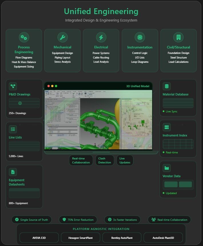
Intelligent 3D Plant & Structural Modelling

We build and maintain intelligent parametric plant and structural models in AVEVA E3D, PDMS, AutoCAD Plant 3D, and Revit — incorporating piping, equipment, structural steelwork, electrical, and instrumentation in a fully coordinated, clash-detected design environment. Every model element is traceable to verified survey geometry, ensuring that design outputs reflect the real asset rather than an idealised approximation.

Clash Detection & Design Coordination

Automated and manual clash detection workflows identify hard, soft, and clearance conflicts across all engineering disciplines before design packages are issued for construction. Clash reports, resolution workflows, and design freeze registers are managed within a structured coordination process — protecting your construction programme from the avoidable delays that undetected clashes invariably produce.

Brownfield Modification & Retrofit Engineering

Brownfield projects carry inherent dimensional risk — existing assets that have shifted, settled, or been modified without updated documentation. We capture the exact as-built condition of your facility, incorporate it directly into the engineering model, and design modifications that fit first time — eliminating the fabrication mismatches and installation failures that make brownfield projects chronically over budget and behind schedule.

What We Deliver

Construction-Ready Design Packages

Fully coordinated, clash-detected design packages — including isometrics, general arrangement drawings, material take-offs,
and fabrication drawings — issued to your construction and procurement teams with confidence
that dimensional accuracy has been verified against the real asset.

Intelligent As-Built Models

Parametric plant and structural models at specified Levels of Development (LOD 200–500), fully updated to reflect the constructed condition and ready for handover into operations, asset management, and digital twin environments — closing the gap between design record and operational reality.

Engineering Data Integration

All engineering outputs are delivered fully georeferenced and structured for direct ingestion into GIS, EAM, CMMS, and digital twin platforms — ensuring that the intelligence embedded in your design model flows seamlessly into your operations, maintenance, and asset integrity workflows from the moment your facility enters service.

Design Change & Revision Management

Structured change management workflows track design revisions, as-built deviations, and field modifications against the baseline model — maintaining a complete, auditable engineering record that supports regulatory compliance, modification management, and lifecycle asset decisions across the full operational life of your asset.

Industries We Serve

industry image

deliver image

Oil & Gas

Pipeline Route Survey | Facility Change Detection | Methane Emission
Monitoring | | Offshore Platform
Surveillance | Oil Spill Detection | SCADA-GIS Integration I AL/ML based Asset Moniroting

industry image

industry image

AEC & Building Documentation

Scan-to-BIM Conversion | Construction Progress Monitoring | As-Built
Verification | Renovation Design Support |
MEP Coordination

industry image

deliver image

Infrastructure & Transportation

Traffic flow simulation I Urban Planning | Citizen Service Mapping |
Emergency Management | Public Health
Mapping I Rail Network Monitoring | InSAR Settlement Monitoring I Digital twin Development

industry image

deliver image

Mining & Quarrying

Mineral Mapping | Open Pit Volume Monitoring | Tailings Dam Surveillance
| Mining Subsidence Monitoring |
Progressive Rehabilitation Tracking | Environmental Compliance Reporting I HSE Virtual Tour

industry image

industry image

Manufacturing & Industrial

Plant Documentation | Equipment Routing | Maintenance Planning | Digital
Twins | Risk Management | VR HSE
Training

industry image

deliver image

Utilities & Networks

Underground Mapping | Route Planning & Conflict Detection | Asset
Documentation | Damage Assessment | Safety
Verification

industry image

deliver image

Coastal, Marine & Hydrographic

Shoreline Change Detection | Satellite Bathymetry | Coastal Erosion
Monitoring | Marine Habitat Mapping | Flood
Inundation Modelling | Sediment Transport Analysis

industry image

industry image

Environmental Management

Environmental Impact Assessment | Habitat Classification | Carbon
Accounting | Water Quality Monitoring | Land
Degradation Assessment | Climate Change Indicators | Sustainability Reporting

industry image

deliver image

Defense, Security & Intelligence

Force Deployment Planning | Terrain Analysis | Border Surveillance
Analytics | Geospatial Intelligence (GEOINT)
And Image Intelligence (IMINT)

Our Methodology: Precision at Every Stage

A proven four-stage process ensuring accuracy, compliance, and actionable insights

deliver image

Plan with Intelligence

Before mobilizing, we begin with a data-driven understanding of your asset environment. We perform a comprehensive site intelligence review — analyzing existing drawings, access limitations, hazardous zones, operational constraints, and required accuracy levels.

deliver image

Precision Field Acquisition with real time QC

Our field teams deploy fully calibrated instruments in strict accordance with manufacturer specifications and project QA protocols. Intelligent workflows deliver real-time on-site feedback on coverage, registration integrity, and data quality

deliver image

AI-Driven Data Processing & Extraction

Curates raw data, Guides AI, Validates Output into actionable digital intelligence through a hybrid pipeline of advanced algorithms, machine learning models, and expert review.

deliver image

Decision-Ready Deliverables

Outputs are not merely models but enterprise-ready information assets. All datasets undergo independent quality assurance audits. We ensure your organization can immediately operationalize the data for planning, maintenance, and strategic decision-making.

Case Studies

We're building a greener tomorrow. Our solutions optimize operations, cut waste, and lower emissions, supporting net-zero goals.

Engineering support

Integrated 3D Engineering for Brownfield Upgrades

Transforming a complex brownfield upgrade through advanced 3D engineering and a fully integrated geospatial platform. Our team combined laser scanning, intelligent modelling, digital twins, and…

3 Sites
Upgraded on a Single Platform
60%
Reduction in Engineering Rework
9 Months
From First Scan to Live Twin
Engineering support

Zero Downtime Equipment Replacement

Transforming shutdown planning through advanced 3D laser scanning and precision modeling. Our team's engineering innovation approach enabled the replacement of 2,000+ spools with zero dimensional…

2,000+
Spools Replaced
100%
Fit-Up Accuracy
Zero
Offshore Rework
Engineering support

Logistic Route Optimization Survey

Transforming offshore plant logistics through advanced SLAM technology and 3D mapping. Our team's rapid route analysis identified optimal pathways for heavy equipment transport, reducing planning…

M-W
Planning Time Reduction
100%
Obstruction Identification
Zero
Transportation Delays

Why Organizations Choose Our Unified Engineering Services

Technical Excellence

Industry-leading accuracy specifications (±1–2 mm TLS, ±2–5 cm aerial) backed by systematic, documented QA/QC processes ensuring reliable, repeatable results across diverse project types — from offshore platforms in extreme marine environments to sensitive heritage interiors.

Operational Efficiency

Multi-platform deployment and AI-accelerated processing compress project timelines by up to 70%. What once required months of manual survey and CAD drafting now delivers registered, classified point clouds and intelligent models in days to weeks.

Integrated Solutions

Complete service delivery from project planning and field acquisition through processing, modeling, and specialized analysis — all under one roof. No fragmented vendor chains, no data conversion losses, no accountability gaps.

Industry Expertise

25+ years of specialized knowledge across regulated, high-stakes environments. We don’t just capture geometry — we understand what it means for your operations, your compliance obligations, and your capital planning decisions.

Proven ROI

Our clients consistently document measurable returns: 30–50% reduction in field rework, 20–40% faster project delivery, elimination of fabrication mismatches, and extended asset service life through predictive condition monitoring. Reality capture isn’t an expense — it’s a multiplier on every downstream decision.

The Integrated Intelligence Advantage

We stand at the intersection of survey engineering precision and enterprise integration — transforming verified field data into connected engineering intelligence that keeps your assets designed accurately, built without rework, and operated with complete dimensional confidence.

Contact Our Specialist

Get in touch to discuss comprehensive terrestrial and aerial laser scanning addressing your project requirements.


Global Operations
24/7 support across multiple time zones