Industrial facilities are complex, high-value environments. Refineries, petrochemical plants, power stations, manufacturing facilities, and offshore platforms are packed with thousands of pipes, vessels, structures, and equipment — all of which must be accurately documented for safe, efficient operations.
Yet for decades, this documentation relied on manual measurements, outdated drawings, and educated guesswork. Engineers worked from paper blueprints that hadn’t been updated since construction. Modifications were designed against dimensions measured by hand — one measurement error away from a costly site rework.
3D laser scanning has changed everything.
At GeoSoft Global, we deliver industrial-grade 3D laser scanning servicesTerrestrial & Aerial Laser Scanning Services | LiDAR Survey & 3D Mapping | Geosoft across the UAE, Qatar, Saudi Arabia, India, and beyond — helping energy companies, EPC contractors, and asset owners capture precise, reliable as-built data for their facilities. In this blog, we explore the key benefits of 3D laser scanning for industrial facilities and why it has become the industry standard for complex brownfield projects.
What Is 3D Laser Scanning for Industrial Facilities?
3D laser scanning — also called LiDAR scanning or terrestrial laser scanning (TLS) — is a non-contact measurement technology that captures the precise three-dimensional shape of a physical environment.
A laser scanner rotates rapidly, emitting millions of laser pulses per second. Each pulse travels to a surface, reflects back to the sensor, and the scanner calculates the exact distance based on the time of flight. The result is a dense point cloud — a three-dimensional collection of millions of precise data points, each with X, Y, and Z coordinates.
For an industrial facility, this means capturing every pipe, beam, vessel, cable tray, and structural element in exact three-dimensional space — with millimetre-level accuracy — in a fraction of the time required by conventional survey methods.
The Top Benefits of 3D Laser Scanning for Industrial Facilities
- Millimetre-Level As-Built Accuracy
The most fundamental benefit of 3D laser scanning is its extraordinary accuracy.
Industrial-grade scanners used by GeoSoft Global achieve accuracies within 1–3 millimetres for local features, and within 5–10 mm over large industrial complexes. This is significantly more reliable than manual measurements, which are subject to human error, restricted access, and cumulative inaccuracies over distance.
For brownfield modifications — new pipelines, structural additions, equipment replacement — this level of accuracy is not optional. A single design clash caused by inaccurate as-built data can result in hundreds of thousands of dollars in rework costs, extended plant shutdowns, and delays to project completion.
With 3D laser scanning, you design against reality — not against drawings that may be 20 years out of date.
- Complete Capture of Complex Environments
Industrial facilities are among the most geometrically complex environments on earth. Overlapping pipe racks, congested equipment areas, multi-level structures, and confined spaces make complete manual documentation near impossible.
3D laser scanning captures everything visible in a single, comprehensive point cloud — regardless of complexity. Every pipe, flange, support, beam, instrument, and fitting is documented in three-dimensional space.
This complete capture becomes the foundation for:
- Engineering design and modification planning
- Maintenance and inspection planning
- Regulatory compliance documentation
- Insurance and asset valuation records
- Dramatically Faster Data Capture
Time is money in industrial environments. Traditional survey methods can take weeks to complete a full plant documentation exercise. Specialist team members must access every area, take individual measurements, and compile the data manually.
3D laser scanning is 10x to 50x faster.
GeoSoft Global teams equipped with modern terrestrial laser scanners can capture a large industrial facility in days. Offshore platforms, refinery units, and process plants that would take traditional surveys weeks to document can be fully scanned — to millimetre accuracy — in a fraction of the time.
This speed translates directly into:
- Shorter plant shutdown periods
- Faster project timelines
- Reduced survey team time on site
- Lower total survey costs
- Non-Intrusive — Scan While the Plant Is Running
One of the most operationally valuable benefits of 3D laser scanning is that it can, in most cases, be carried out while the plant is live and in production.
Unlike traditional surveys that often require equipment isolation, work permits, and shutdown coordination, laser scanning is a non-contact, non-intrusive process. GeoSoft survey teams set up scanner positions around the facility and capture data without touching, modifying, or interrupting plant operations.
This is particularly valuable for:
- Operating refineries and petrochemical plants
- Live power stations and substations
- Offshore platforms in production mode
- Manufacturing facilities running 24/7
The result is near-zero production impact during survey activities.
- Safer Surveys — Reduced Personnel Exposure
Industrial facilities contain numerous hazardous zones: confined spaces, elevated platforms, toxic atmospheres, high-temperature equipment, and electrical hazards. Sending surveyors into these areas for traditional measurements carries significant safety risk.
3D laser scanning fundamentally changes the risk profile of industrial surveys.
Because the scanner collects data remotely at distances of up to 350+ metres, surveyors can capture detailed geometric information from hazardous areas without physically entering them. A single scanner position outside a congested area can capture the complete geometry of the space inside.
For HSE-critical operations in the UAE and GCC — where Zero Harm policies are non-negotiable — this safety benefit alone often justifies the switch to laser scanning.
- One Survey, Unlimited Deliverables
The 3D point cloud captured by laser scanning is not a single-use dataset. It is a permanent, reusable digital asset that can be processed into any engineering deliverable your team requires:
- 3D BIM models (Revit, Navisworks, OpenBIM formats)
- 2D engineering drawings — plan, section, elevation, isometric
- Pipe isometrics for fabrication and installation
- Clash detection models to identify conflicts before construction
- Structural steel and civil models
- Digital twin geometries for intelligent asset platforms
- Volumetric calculations for tanks, stockpiles, and vessels
This “capture once, deliver many” approach maximises the return on every survey investment.
- Clash Detection and Zero Rework
When new infrastructure — pipes, vessels, modules, structures — is designed using a precise 3D model of existing conditions, clashes can be detected and resolved before a single piece of material reaches the site.
This is one of the highest-value applications of 3D laser scanning for industrial facilities. Industry studies consistently show that design clashes discovered on-site cost 10–100 times more to resolve than those identified and corrected during design.
GeoSoft Global delivers clash-detection-ready point clouds and BIM models that integrate directly with engineering platforms such as AVEVA, PDMS, E3D, AutoCAD Plant 3D, and Revit — ensuring your engineering and construction teams work from a single, accurate geometric baseline.
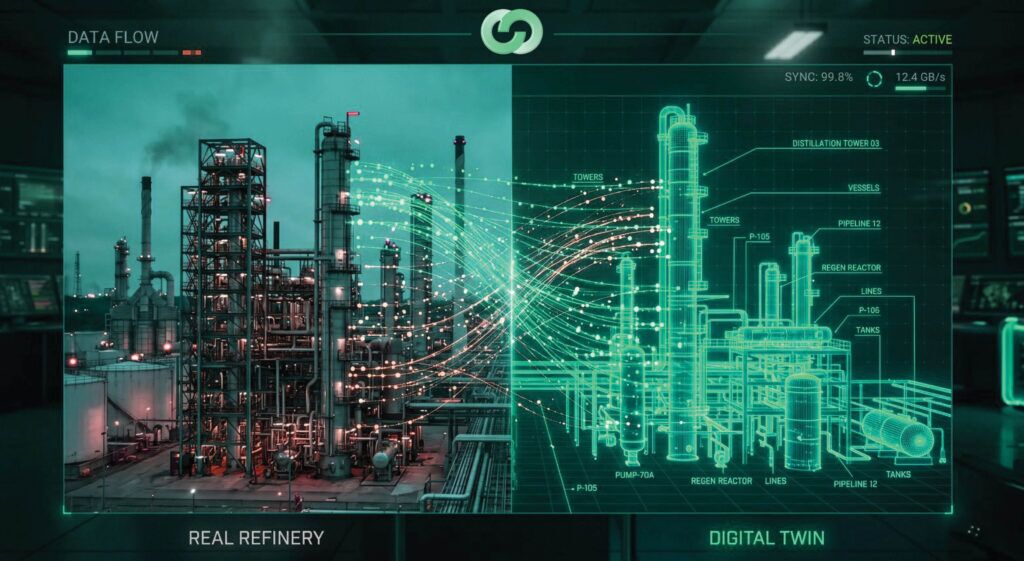
- The Foundation for Digital Twins
A digital twin is a dynamic, intelligent replica of a physical asset — connected to live operational data, capable of simulation and analysis, and used across the full asset lifecycle. Digital Twin Solutions & 3D Modeling | Geosoft Global
Every digital twin starts with accurate 3D geometry.
The point clouds and BIM models produced from 3D laser scanning form the geometric backbone of digital twin implementations for industrial facilities. These scan-derived models provide:
- Precise geometry for every asset and system
- A baseline for change detection and deformation monitoring
- Integration points for IoT sensors, SCADA, and maintenance systems
- The visual environment for operator training and remote inspection
At GeoSoft Global, our digital twin services build directly upon our 3D laser scanning capabilities — ensuring that your digital twin accurately represents the real-world state of your facility from day one.
- Brownfield Project Planning — Design to Reality
Brownfield modifications and expansions are among the most challenging phases of any industrial facility lifecycle. You are adding new infrastructure to an existing, often congested, operating plant — with zero tolerance for clashes, interferences, or incorrect dimensions.
3D laser scanning is now the industry standard preparation step for brownfield projects because it answers the most critical question in brownfield design: “What exactly is there?”
Common brownfield applications for GeoSoft Global clients in UAE, Qatar, and India include:
- New process unit tie-ins and expansions
- Pipeline route planning through congested rack areas
- Module and skid installation — dimensional control and virtual fit-up
- Structural modifications and new equipment installations
- Revamp design for ageing process plants
- Progressive Long-Term Asset Record
Industrial facilities change continuously through modifications, repairs, additions, and operational adjustments. Regular laser scanning campaigns create a progressive digital record of the facility as it evolves — ensuring that as-built documentation always reflects current conditions.
GeoSoft Global supports clients with periodic change-capture scanning campaigns that update existing 3D models and point clouds to reflect completed modifications. This living digital record of the facility becomes one of its most valuable engineering and operational assets.
Whether you need an as-built survey for a single process unit, a complete plant documentation exercise, or a digital twin foundation for your entire facility — GeoSoft Global delivers the precision data your team needs, on time and to specification.
3D Laser Scanning, LiDAR & Digital Twin Solutions | Geosoft Global
Frequently Asked Questions (FAQs): 3D Laser Scanning for Industrial Facilities
Q1: What is 3D laser scanning in the context of industrial facilities?
3D laser scanning uses a precision laser sensor to capture millions of distance measurements around an industrial plant, generating a dense three-dimensional dataset called a point cloud. This point cloud represents every visible surface — pipes, equipment, structures, cable trays, and architectural elements — in precise 3D space. The data is then processed into engineering deliverables including BIM models, 2D drawings, pipe isometrics, and digital twin geometries.
Q2: How accurate is industrial 3D laser scanning?
Industrial-grade terrestrial laser scanners typically achieve point accuracy within 1–3 mm for close-range features and 5–10 mm across large industrial complexes. This is far more accurate and repeatable than conventional manual survey methods, which are prone to cumulative human error — particularly in complex, congested industrial environments. GeoSoft Global’s survey teams verify all scan data against established control networks to guarantee accuracy compliance for each project.
Q3: Can 3D laser scanning be done while the plant is operating?
Yes — in the vast majority of cases, 3D laser scanning can be carried out while the industrial facility is live and in normal operation. Because laser scanning is a non-contact, remote measurement process, surveyors do not need to touch or access the equipment being scanned. Only specific high-risk or extremely hazardous zones may require isolation. This means minimal disruption to production — one of the most significant operational advantages of laser scanning over traditional survey methods.
Q4: How long does a 3D laser scanning project take for an industrial facility?
Project duration depends on facility size and complexity. A single process unit or module may be captured in one or two days. A large refinery complex or multi-unit plant may require one to two weeks of scanning. This is dramatically faster than traditional survey methods, which could take months for the same coverage. GeoSoft Global provides detailed project programmes including scan duration, processing time, and deliverable deadlines for each engagement.
Q5: What deliverables can I expect from a GeoSoft Global laser scanning project?
GeoSoft Global can deliver a range of outputs from a single laser scanning campaign, depending on your project requirements:
- Registered, colour-rendered point cloud data (RCP, E57, RCS, XYZ formats)
- 3D BIM models (Revit, Navisworks, AutoCAD Plant 3D, OpenBIM)
- 2D engineering drawings — plans, elevations, sections, and isometrics
- Pipe isometrics for fabrication
- Clash detection models for brownfield design review
- Digital twin-ready geometry and metadata
- Structural steel and civil engineering models
- Dimensional control reports for offshore module fit-up
Q6: How does 3D laser scanning support digital twin implementation?
A digital twin requires an accurate geometric foundation. The point cloud and BIM model derived from 3D laser scanning provide this foundation — capturing the precise as-built state of the physical facility. GeoSoft Global’s digital twin services build upon scan data to integrate live sensor feeds, maintenance records, and operational data — creating an intelligent, live replica of the facility that supports predictive maintenance, remote operations, and lifecycle asset management.
Q7: What industries and facility types does 3D laser scanning apply to?
3D laser scanning is applicable across all industrial sectors: oil and gas refineries, petrochemical and chemical plants, power generation facilities, offshore platforms and FPSOs, manufacturing plants, storage terminals, utilities, marine structures, and infrastructure projects. If your facility has complex geometry, existing conditions that need to be accurately documented, or modification work requiring precise as-built data, 3D laser scanning is the right technology.
Q8: Is 3D laser scanning suitable for offshore platforms and marine vessels?
Yes — offshore platforms, jack-ups, FPSOs, and marine structures are among the most demanding environments for dimensional surveys, and laser scanning is ideally suited to these applications. Remote, non-contact scanning minimises time in hazardous areas. GeoSoft Global has extensive offshore survey experience and uses laser scanning alongside dimensional control techniques to support complex module installations, deck additions, and marine asset surveys — enabling virtual fit-up and confirming first-time installation success.
Q9: How does 3D laser scanning reduce costs for brownfield industrial projects?
3D laser scanning reduces costs in brownfield projects through several mechanisms. Accurate as-built data eliminates design errors and the site rework they cause. Faster survey completion reduces survey team costs and plant shutdown time. Early clash detection eliminates costly last-minute design changes and construction modifications. Precise prefabrication data reduces onsite cutting and welding. Industry experience consistently shows that the cost of a laser survey is many times smaller than the cost of a single significant design clash discovered on site.